
I am continuing to explore the old map of Portsmouth (Town Bank, NJ) that depicts one of the first European settlements on the Delaware Bay.
The settlers of Portsmouth chose to build on the high-and-dry sandy maritime forest that was surrounded by hardwood swamps and tidal marshes. From the sand bluffs along the shoreline they could see the comings and goings of the whales that they hunted.
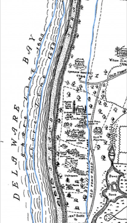
One aspect of the coastal geology the settlers did not account for is the constant erosion of these bluffs over time. The set of lines on the map below depict the shoreline at different time intervals (1605,1648 and 1868). It shows us that coastal erosion is not just a modern phenomenon.
The 1868 line was drawn in by hand long after the map was originally produced. There is very little left of the footprint of the original settlement. The dune forest settlers built upon has sloughed off into the Bay. We’ve lost about a half mile of land according to the Portsmouth map.
(Use the slider to shift between maps)
The tall sandy bluffs and dunes of the area have continually eroded into the bay and the shoreline has retreated. Although development has now locked up the shoreline in Town Bank, this erosional process continues just south of the map at Higbee Beach.
Paul Kerlinger recently asked the question, “Are we losing Higbee Beach?”
The answer is yes and no. We are losing dune bluffs (as we always have) but the sand from those bluffs will nourish the beach itself. Losing large volumes of sand from these bluffs might actually be a good thing for Delaware Bay beaches.
Beaches need a source of sand to help maintain them. For the Bay, that source for beaches to the north might be the eroding sand bluffs of Cape May and Town Bank. This natural nourishment may be a key to maintaining habitat for spawning horseshoe crabs and shorebirds.

The erosion, from 1726 until now, is a natural process that is, in part, a result of local sea level rise that has been occurring at a gradual rate (a few millimeters per year) since the last ice age (roughly 10,000 years ago). Everything, dune forests and settlers alike, have had to retreat form the shore as it has crumbled into the bay.
Read more about the post-glacial processes that drive local sea level rise here.