Shoreline erosion is happening very rapidly on the Delaware Bay.
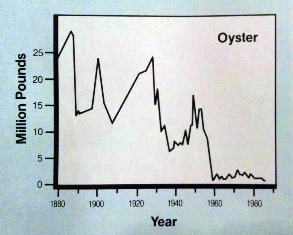
One estimate of loss is 3.2 meters per year between 1940 and 1978 (Phillips 1986). We can be sure that this rate has not slowed down since then.
It is easy to point the finger at sea level rise, but there is often more to it than that.
The Delaware Bay landscape, as wild and natural as much of it seems, has a distinctly different character than what an early colonist would have seen.
Most stretches of coastline bear a long history of human meddling. And this meddling has in many cases affected the character and condition of these places as well as their resilience to storms and sea level rise.
Getting to this understanding is important because reversing the impacts of past human meddling can help provide a clear restoration rationale, in this case for taking action to stem shoreline erosion.
Shoreline erosion is nothing new
Before going further, I must emphasize that the changes we are seeing in the Delaware Bay and elsewhere in the region are nothing new. Eroding shorelines and uplands overtaking marsh have been happening since the end of the last ice age.
Historical descriptions are at least as alarming as what we are seeing today. Writing in the post-Civil War era, Maurice Beesly reports:
Christopher Ludlam, father of Charles Ludlam, Esq., located 40 acres of meadows in 1801 on the western side of said [East] creek, which from the minutes of the deed ran up it a straight course 100 perches to a ditch passing westward from the creek at right angles. In 1869 I visited the spot and found the whole tract of 40 acres had been swallowed up by the capacious maw of the bay, and exists only in the shape of atoms. Therefore, if 100 rods has been washed away in sixty-eight years, we find the average loss one and a half rods a year.
One and a half rods per year is equivalent to 7.5 meters per year, estimated in 1869.
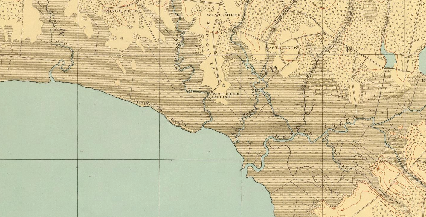
A similar pattern in the same region is reported by the New Jersey State Geologist in 1840:
During the past season, while in the southern part of the State, my attention was frequently called to the rapid wearing away of the shores, and to the advance of the tide-waters on the land. Local causes were generally assigned for the increased height of the tides; but this and other phenomena were extended over so long a line of shore, that it was thought there must be some general cause for them; and this cause appears to be, the slow but continued settling or subsidence of the land. At the mouth of Dennis creek, in Cape May County, and for several miles along the bay-shore, on each side of it, according to the local surveyors, the marsh wears away, on an average, about one rod in two years; and, from the early maps, it would appear to have been going on at that rate ever since the first settlement of the country.
A half a rod per year translates to 2.5 meters per year, estimated in 1840.
These 19th century estimates of shoreline erosion rates are not far off from Phillips’ 1940-1978 estimate.
Yet Phillips (1986) points out that sea level rise alone and the resulting readjustment of the shoreline would not result in such a high rate of shoreline retreat. He predicted that this number would be more like 0.7 meters a year.
For comparison, the rate of shoreline erosion along the Delaware Bay surpasses that of Louisiana, which loses wetlands at a rate 0.8–1.38 meters per year (as a result of human meddling, i.e., sediment diversion, etc.).
Sea level rise + waves
The Delaware Bay is not a placid bathtub. Although ocean-swell waves are absent, the broad expanse of water allows wind-generated waves to form.
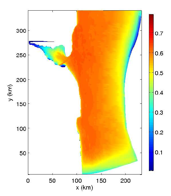
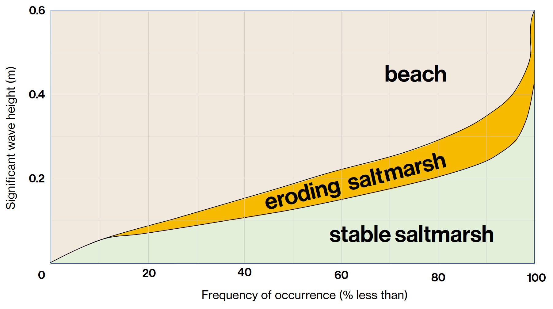
Waves are a big factor in coastal erosion, particularly in stretches of shoreline that are bordered by marsh rather than beach. Beaches can take a pounding, but salt marsh is easily eroded by nipping waves.
When median wave height exceeds six inches, a salt marsh shoreline will be in retreat. Waves in the Delaware Bay easily exceed this threshold, depending on wind direction.
From Roland and Douglass 2003
Sea level rise + waves + meddling
In the mid-1800s the coastal landscape was, by then, far from pristine. Human meddling along the Delaware Bay’s shoreline may have actually been at its peak then.
Two forms of meddling may have exacerbated our erosion problem.
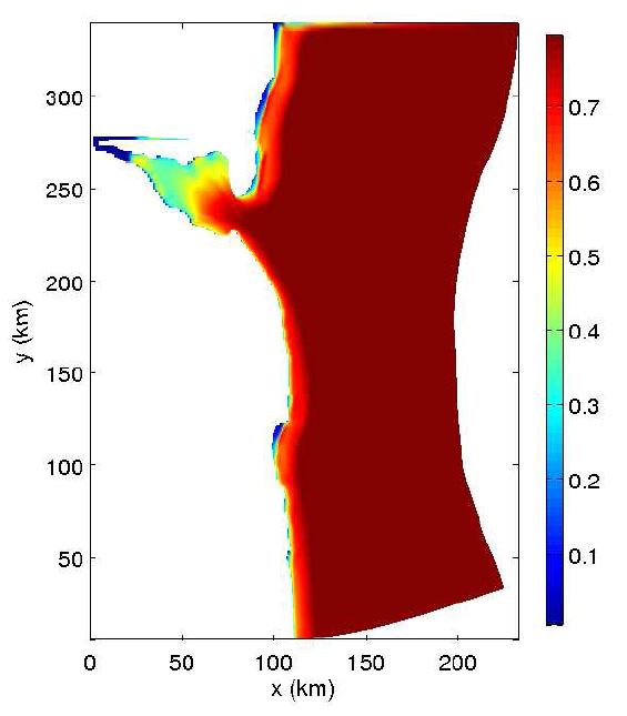
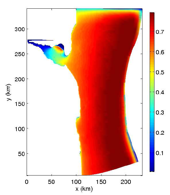
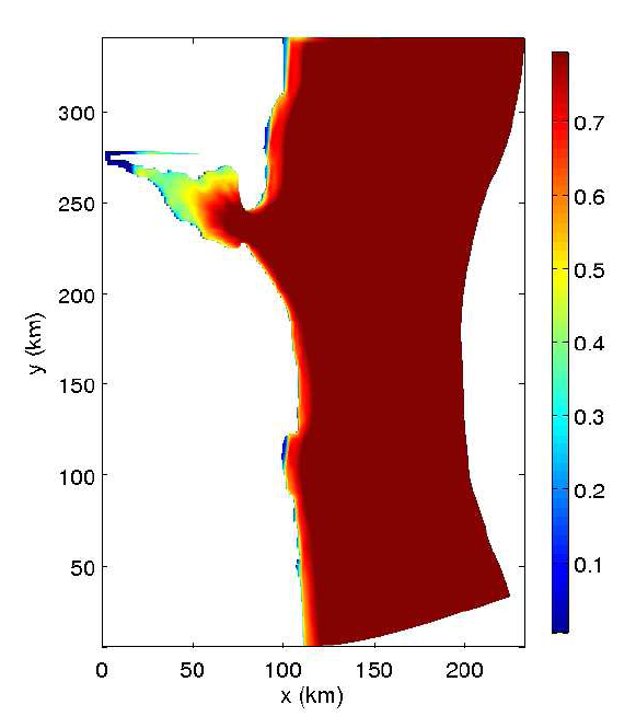
First, the widespread diking of marsh for farming created a more fragile shoreline. Diking caused peat to break down and as a result, marsh elevations dropped significantly over time. Once dikes were abandoned or moved inland, the marshes were more vulnerable to erosion.
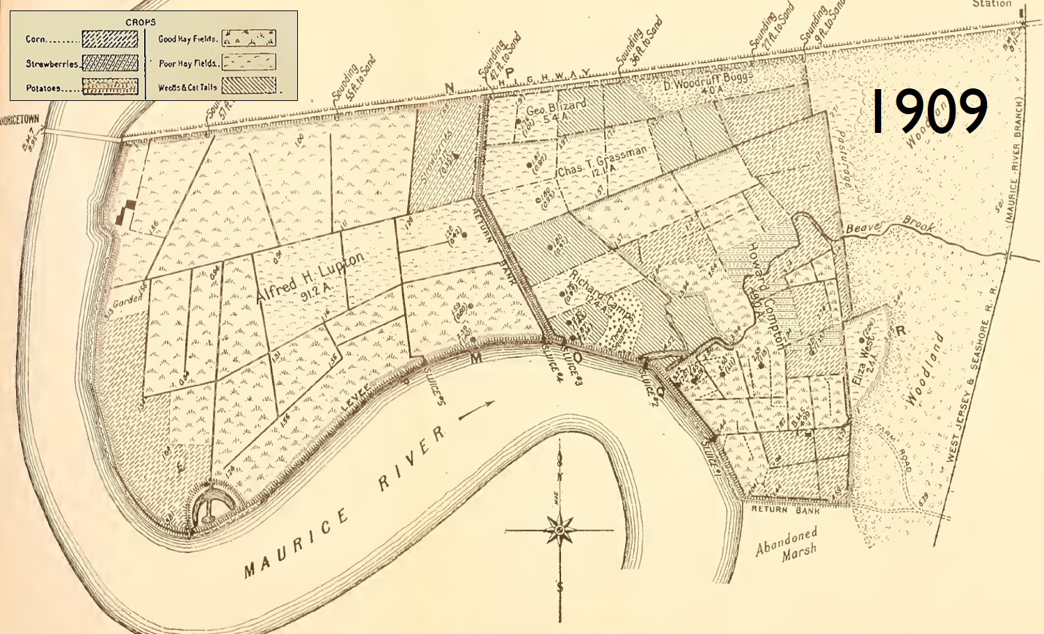
In formerly farmed stretches of shoreline, both the past and predicted future rate of edge erosion is greater than areas of shoreline that were never diked (Lathrop and Smith in review).
A second, more speculative possibility is that the loss of widespread oyster reefs has exposed the shoreline to increased wave action.
Oysters are a key component of modern-day “living shorelines,” where people hand-build shell piles along the shoreline to encourage colonization and growth of oysters that will in turn shelter the shoreline from waves.
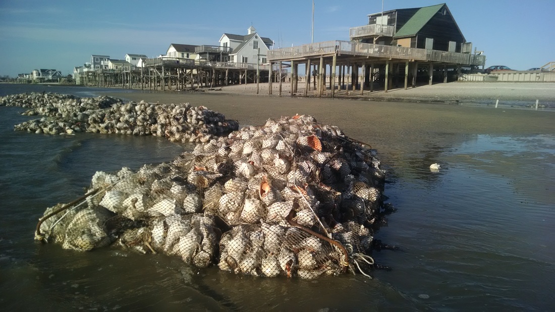
It stands to reason that extensive precolonial wild reefs would serve the same function.
Delaware Bay oysters before overexploitation
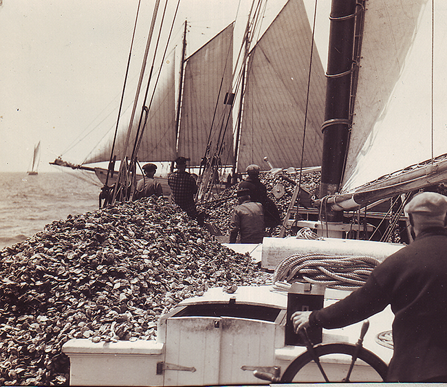
Oysters in the Delaware Bay and elsewhere in New Jersey now have a marginal presence, occurring mainly on intensively managed seed and leased beds. Three-dimensional reef structures are now rare and it is uncommon to see oysters close to shore in the marshes and intertidal zone.
Historical accounts paint a completely different picture. In 1880, Ingersoll reported that:
The entire shore of Maurice Cove is bordered by extensive marshes, through which innumerable creeks find their way from the interior, and which contains many open places called “ponds.” Through these creeks and ponds, in the tide ways and along the borders of the sedge plats and islands, oysters have always grown in great profusion.
From this, it sounds like the shoreline was indeed alive with oysters.
Beyond the shoreline, in deeper water, Ingersoll tells us that:
The bottom of the bay, and of the Delaware River from Cape May Beach clear up to a little above Cohansey Point, a distance of not less than fifty miles, is everywhere spotted with oyster beds. The same is true of the opposite, or Delaware shore. These oyster beds are not confined to the shallow waters near shore, or to the sedge plats, but are apparently scattered over the whole bottom of the bay.
It is very difficult to get beyond these few subjective descriptions in establishing a baseline for the extent of oyster reefs prior to exploitation.
Oysters showed signs of overfishing as early as the 1700s, when the first harvest restrictions were put in place. The introduction of the oyster dredge in the early 1800s destroyed the three-dimensional structure of wild reefs. Oysters in the shallow water near marshes were harvested for seed, and seed importation from the Chesapeake Bay became common by the 1830s to supplement flagging local stocks.
The ability of oysters to bounce back on their own was limited by the constant removal of shell, which was used for paving roads and making lime.
In an unfished, undredged environment, a living layer of oysters rests on a core of old shell, established over centuries, that provides a stable reef base in the bottom sediment and forms a three-dimensional structure that can reach up from the bottom to the mean tide level.
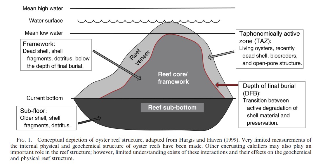
Figure from Waldbusser et al. 2013
The wave-dampening power of oyster reefs?
The dramatic shoreline erosion rates observed in the 1800s were noted after the establishment of diked farms and after the loss of extensive oyster reefs. Were these people observing a first shockwave of rapid erosion after the reefs were removed and the marsh was damaged?
Calculations show that a reef structure which reaches the mean tide level will reduce wave heights by 50%. This is enough to knock down wind-driven waves to heights that are below the threshold that would trigger marsh erosion.
In addition to reefs in deeper water, oysters fringing the shoreline as described in the historical account of the Maurice River area may have also helped salt marshes resist erosion.
The rationale for restoration
The potential for restoring oysters to their former extent is low, at least in a time-frame that would help staunch the loss of marsh. All kinds of regulatory, financial, and biological hurdles exist.
Perhaps the biggest impediment is the lack of shell in the water after centuries of removal. A massive infusion of shell would be necessary to give the oyster population the capacity to recover.
But this doesn’t mean that we can’t selectively establish projects designed to mimic the function of oyster reefs to shelter shorelines.
We aren’t certain that current-day erosion rates have been exacerbated by the loss of natural oyster reefs. But this notion is certainly plausible given what we know about the historical extent of oysters and their capacity to reduce shoreline erosion.
This, combined with our knowledge that the past history of marsh farming has exacerbated erosion, offers a restoration vision: that erosion may be an act of God, but it has been made worse by the actions of people. In other words, past actions by people have reduced the present-day resilience of the shoreline to sea level rise.
This reality means that people have the power, and maybe the responsibility, to do something to improve the situation.
REFERENCES
Abbott, C.C. & Lewis, H.C. (1881) Primitive Industry: Or, Illustrations of the Handiwork, in Stone, Bone and Clay, of the Native Races of the Northern Atlantic Seaboard of America. G.A. Bates.
Borsje, B.W., van Wesenbeeck, B.K., Dekker, F., Paalvast, P., Bouma, T.J., van Katwijk, M.M., & de Vries, M.B. (2011) How ecological engineering can serve in coastal protection. Ecological Engineering, 37, 113–122.
Feagin, R.A., Lozada-Bernard, S.M., Ravens, T.M., Möller, I., Yeager, K.M., & Baird, A.H. (2009) Does vegetation prevent wave erosion of salt marsh edges? Proceedings of the National Academy of Sciences, 106, 10109–10113.
Ingersoll, E. (1881) The Oyster Industry. U.S. Government Printing Office.
Lathrop, R.G. & Smith, J.A.. (In review) Implications of Shoreline Change and Sea Level Rise on the Delaware Bay for wildlife habitat. Wader Study.
Powell, E.N., Klinck, J.M., Ashton-Alcox, K., Hofmann, E.E., & Morson, J. (2012) The rise and fall of Crassostrea virginica oyster reefs: The role of disease and fishing in their demise and a vignette on their management. Journal of Marine Research, 70, 505–558.
Qin, W., Kirby, J.T., & Badiey, M. (2005) Application of the spectral wave model SWAN in Delaware Bay. University of Delaware.
Rogers, H.D. (1840) Description of the Geology of the State of New Jersey: Being a Final Report. C. Sherman & Company, printers.
Roland, R.M. & Douglass, S.L. (2005) Estimating Wave Tolerance of Spartina alterniflora in Coastal Alabama. Journal of Coastal Research, 21, 453–463.
Smith, J.A.M., Hafner, S.F., & Niles, L.J. (2017) The impact of past management practices on tidal marsh resilience to sea level rise in the Delaware Estuary. Ocean & Coastal Management, 149, 33–41.